


America's Coolest Hometown
Marion/Smyth County, Va.
Just seven miles away from the Appalachian Trail in the highlands of Southwest Virginia, Marion and Smyth County offer unlimited outdoor recreational opportunities from the Appalachian Trail itself to the Jefferson National Forest, the Mount Rogers National Recreation Area, Grayson Highlands and Hungry Mother State Park wrapped around the certified Virginia Main Street community with the nationally-recognized historic downtown. Marion is proud to call itself “Your Home in the Heart of the Highlands!”
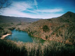
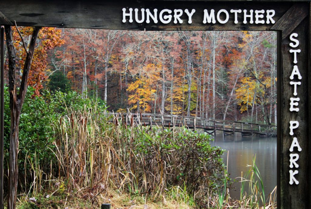
- Go for a swim, take a hike, cast a line, or even fly through the air at one of Virginia’s very first state parks, Hungry Mother State Park. The Park’s 108-acre lake features a sandy beach popular for swimming, as well as boat rentals and great fishing spots. With 17 miles of trails, you can take a leisurely stroll along the shore or climb all the way to the summit of Molly’s Knob for panoramic views. Just outside the park, Hungry Mother Adventures offers thrilling zipline tours that include the highest, longest, and fastest zipline in the state of Virginia.
- Enjoy a nationally-televised Song of the Mountains concert in downtown Marion‘s historic Lincoln Theater! Concerts are filmed once a month, so if you time your visit right you can catch the region’s brightest stars performing traditional and contemporary old time and bluegrass music. But even if you miss Song of the Mountains, be sure to see what else is going on at the Lincoln Theater, which celebrates its 90th year in 2019. Stay at the Francis Marion Hotel or the Collins House Inn, and you’ll be just footsteps from the show.
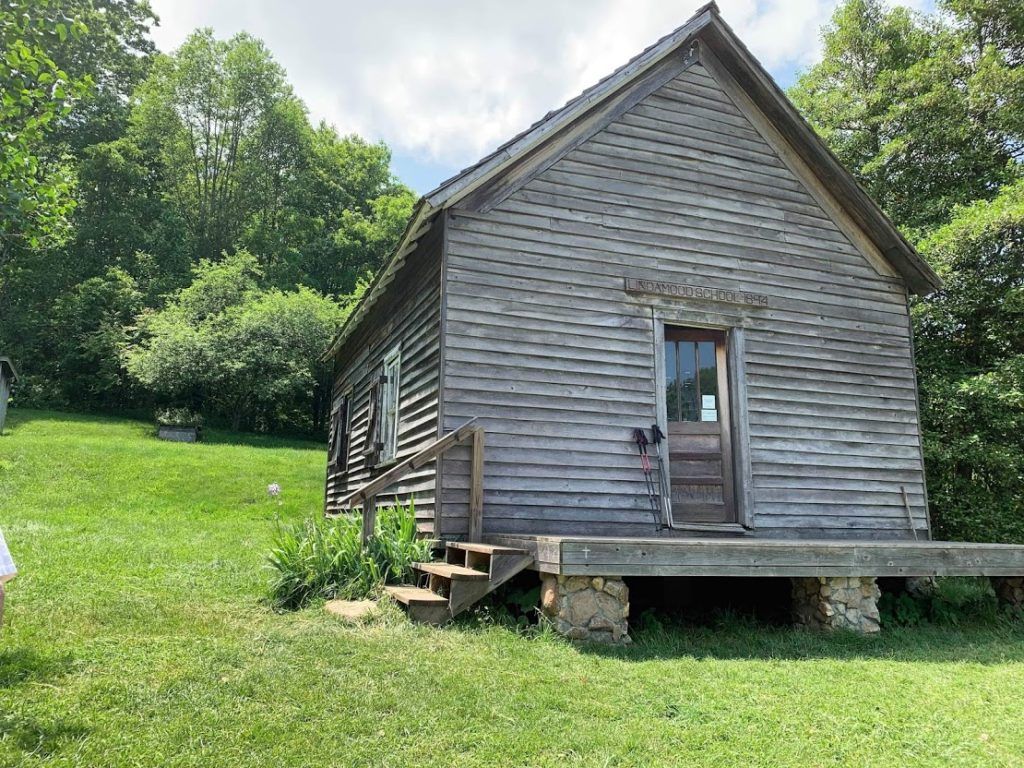
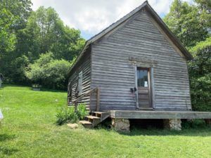 Add some local flavor to your hike in the Davis Valley, and stop by the Davis Valley Winery & Distillery. Located less than a mile from the A.T., a tasting is a great addition to a stroll through the beautiful fields and forests of Smyth County. While you’re in the area, be sure to visit the Settlers Museum for a glimpse of life 100 years ago – the A.T. passes right by the historic 1894 one-room schoolhouse. For a truly unique lodging experience, spend a night at the Long Neck Lair Alpaca Farm nearby!
- Find a classic small-town experience at Park Place Drive-In Movie Theater! Not only can you catch an open-air movie every Friday and Saturday, April through September – there’s also an ice cream parlor and miniature golf.
- Learn something new at the Wayne C. Henderson School of Appalachian Arts. From mountain music jams to art classes, there’s always something going on at The Henderson in downtown Marion. Check the schedule to see what you can drop in on during your visit: http://thehenderson.org/
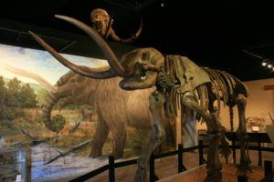 Step through the window of time at the Museum of the Middle Appalachians: “From the Ice Age to the Space Age.” Learn how geology has influenced the area’s history for millions of years. See the full-size replicas of ice age mammals that roamed the region over 15,000 years ago. Visit the site of annual archeological and paleontological digs and see artifacts and fossils that reveal the story of the ancient past. View a display of Woodland Indian artifacts that includes an extensive collection of bead work and tools. In the Salt Theater see five video programs about the role of the Salt Works in the Civil War and the two battles fought at “The Salt Capital of the Confederacy”. Learn about Saltville’s industrial history, where the American chemical industry began, and life in the company town that developed around it. Study a unique eco-system of a salt-water marsh located 400 miles from an ocean. Whether you’re a native of the area, a visitor, a research student, or just passing through, you will find something of interest. Browse the seventeen natural and cultural salt related exhibits of Appalachian heritage and history taking you “From Mammoths to Moon Missions.” It’s an unexpected experience.
• Long Neck Lair Alpaca Farm
• Marion Outdoors
These businesses support the Trail by taking part in the A.T. Community Supporter program.


Featured Local Hikes
Hike 1: Settlers Museum to view of the Great Valley:
Route Type: Out and Back
Hike Difficulty Rating: Moderate to Strenuous
Hike Length: 6.6 miles
Description: The route described here takes you from the grounds of the Settlers Museum of Southwest Virginia, south on the Appalachian Trail to a grandstand view of the Great Valley of Virginia on Glade Mountain. This route climbs 1,200 feet over occasionally rocky terrain. Visitors looking for an easier or shorter hike might prefer to follow the A.T. north as it crosses the Great Valley through a mix of field and forest.
The Settlers Museum is open April 2 through October 31, except on Mondays. If the museum is open, plan to tour the grounds at the beginning or end of your hike. A self-guided tour brochure can be obtained at the Visitor Center, with interesting information about the restored farmhouse and 9 outbuildings. Find the Appalachian Trail between the Visitor Center and the historic 1894 Lindamood Schoolhouse.
From the one-room schoolhouse, follow the A.T. south, away from the road and into the woods. Pass under powerlines at 0.3 miles, then begin to climb Glade Mountain through a lush forest with frequent access to the tumbling waters of Vaught Branch. At 1.6 miles, cross U.S. Forest Service Road 644, and in another 0.3 miles pass by Chatfield Memorial Shelter which offers an excellent opportunity for a mid-hike break. At 3.3 miles, arrive at an opening in the rhododendrons which offers expansive views to the west, down the Great Valley and across to Walker Mountain. After taking in the view, return to the Settlers Museum the same way you came.
Driving Directions: This hike starts and ends at the Settlers Museum of Southwest Virginia, located at 1322 Rocky Hollow Rd, Atkins, VA 24311. From Interstate 81, take exit 54 for Groseclose. Follow signs from the exit to turn onto US-11 South, passing by an Exxon and a Sunoco station. From US-11 South, take your first left onto VA-683/Phillipi Hollow Road. Follow Phillipi Hollow Road for 1.5 miles, then turn left onto VA-615/Rocky Hollow Road. The Settlers Museum parking lot will be on your right in 0.2 miles.
Hike 2: Lake Loop at Hungry Mother State Park
Route Type: Loop
Hike Difficulty Rating: Easy to Moderate
Hike Length: 6 miles
Description: Hungry Mother State Park is one of the original six Virginia State Parks, a beloved destination for families and anyone who enjoys exploring the great outdoors. This hike takes you all the way around Hungry Mother Lake in the heart of the Park, with views across the water of the mountains rising all around. Visitors looking for a shorter hike could do an out-and-back section of the Lake Trail, while hikers ready for a challenge may want to take on the strenuous climb to the Park’s high point, Molly’s Knob. A guide to all the well-marked trails in the Park can be obtained at the Visitor Center.
If entering the Park from Marion, you’ll pass several access points to the Lake Trail along Route 16 with parking options, but it’s best to continue to the Discovery Center for a trail guide and map. From the Discovery Center, cross the road to access the Lake Trail loop and turn right to follow the trail counter-clockwise, toward the dam.
This 5.7-mile trail for hiking and biking closely follows the edge of the lake. It makes brief diversions along ridges and away from the shore where it connects to the Ridge and C.C.C. trails. This relatively wide trail features numerous changes in elevation and many sharp turns and switchbacks resulting in constantly changing vistas of the lake and surrounding mountains. Shady thickets of rhododendron, dense leafy forest, cool creek beds and abundant wildlife make this trail an interesting and ever-changing panorama. This loop trail starts and ends at 2,212 feet. The first mile, which parallels Park Blvd., is gently rolling and relatively flat. Once the trail crosses the dam, it begins steeper rolling sections. The section along the back side of the lake has significant elevation gain and loss. The trail’s highest point is at 2,374 feet.
Driving Directions:
To get to the park, take Exit 47 from Interstate 81. Travel approximately one mile on Route 11 toward Marion. Turn right on Route 16 north and travel four miles to the park. Register at the Discovery Center.
The park’s address is 2854 Park Blvd., Marion, Va. 24354-9323; Latitude, 36.882561. Longitude, -81.533867.
Get Involved
 Mount Rogers Appalachian Trail Club
The Mount Rogers Appalachian Trail Club maintains 59.4 miles of the Appalachian Trail from the TN/VA line north to the South Fork of the Holston bridge, Rte. 670, in Teas, VA. The club welcomes guests on Trail work trips and recreational hikes. Visit www.mratc.org for schedule and more information.
 Piedmont Appalachian Trail Hikers
An all-volunteer group, Piedmont Appalachian Trail Hikers (PATH) is responsible for maintaining roughly 65 miles of the Appalachian Trail in southwest Virginia, from VA-670 in Teas, VA to US-52 above Bland, VA.
Gorgeous mountains, 6 pristine valleys, 2 mountain gaps, clear rivers and streams, stellar vistas, abundant wildlife, working farms, historical sights and much more will greet you each and every day. Including 3 Wilderness areas, 1 Wilderness study area & 1 Proposed National Scenic area. Learn more and become a member today at path-at.org.
ATC Volunteer Program
The Appalachian Trail Conservancy is always looking for dedicated volunteers to help maintain the A.T. and assist in our visitor center and headquarters. Opportunities range from greeting visitors and providing information about local hikes to joining a Trail crew for week-long maintenance trips, gaining first-hand experience in what it takes to keep the A.T. open and enjoyable for millions each year. Learn more at appalachiantrail.org/volunteer.
Learn More
Click here for more information about the Town of Marion, and
Click here for more information about Smyth County.
Discover More

Roan Highlands Haven
Appalachian Balds are for the Birds
The iconic bald mountains along the Appalachian Trail in North Carolina and Tennessee are significant to the future of migratory and resident birds.

By Jennifer Pharr Davis
Scenic Views
Wide-open vistas beyond the footpath offer respite and are essential to the Wild East.
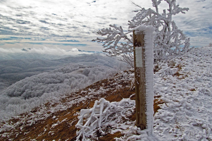
Hiking Tips
What to Know Before You Go
Wide-open views, crisp air and solitude make for a cool hike, but when winter hiking, being prepared is key.